
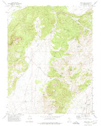
1971 Map of Buckhorn Flat
USGS Topo · Published 1974About this map
Water sources define the settlement and grazing potential of Buckhorn Flat in this early 1970s survey. Located within the Parowan Valley, the landscape is dotted with critical infrastructure for ranching, including the Goodman Well, Government Well, and several Flowing Wells. The terrain transitions from the high peaks of the Black Mountains and Shimhi in the west toward the imposing Hurricane Cliffs to the east. Several named landmarks such as Muley Point and Swayback Knoll rise above the flat, while drainage follows systems like Fremont Wash and Lees Wash. Evidence of land management is visible through the CCC Pond and a network of Jeep Trails that navigate through Little Valley and Dennis Hollow. These features reflect a mid-century reliance on managed groundwater and established livestock routes across the Iron County desert.
Find a feature on this map
25 named features on this map. Tap any name to fly to it.
Don’t see what you’re looking for? This feature index may not catch every label — zoom into the map to look around manually.
Map Details
Editions of this 1971 Buckhorn Flat Map
This is the sole edition of this map. No revisions or reprints were ever made.
Other maps of this area

1885 · Beaver
USGS Topo · 1:250,000

1886 · Kanab
USGS Topo · 1:250,000

1953 · Richfield
USGS Topo · 1:250,000

1953 · Cedar City
USGS Topo · 1:250,000

1958 · Richfield
USGS Topo · 1:250,000

1958 · Cedar City
USGS Topo · 1:250,000

1958 · Minersville
USGS Topo · 1:62,500

1962 · Cedar City
USGS Topo · 1:250,000

1971 · Paragonah
USGS Topo · 1:24,000
1971 · Burnt Peak
USGS Topo · 1:24,000