1971 Map of Paragonah
USGS Topo · Published 1974About this map
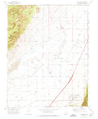
The town of Paragonah sits at the base of the Hurricane Cliffs in the early 1970s, where the eastern mountains meet the expansive Parowan Valley. The settlement is defined by its agricultural grid, supported by a vast network of water sources including Wheatgrass Flowing Well and numerous other flowing wells scattered across the valley floor. The landscape transitions from the high elevations of Jackrabbit Mountain and Black Knoll down to the alkaline flats of Little Salt Lake in the west, illustrating the critical relationship between mountain runoff and desert basin survival.
Find a feature on this map
28 named features on this map. Tap any name to fly to it.
Don’t see what you’re looking for? This feature index may not catch every label — zoom into the map to look around manually.
Map Details
Editions of this 1971 Paragonah Map
This is the sole edition of this map. No revisions or reprints were ever made.
Other maps of this area

1885 · Beaver
USGS Topo · 1:250,000

1886 · Kanab
USGS Topo · 1:250,000

1953 · Richfield
USGS Topo · 1:250,000

1953 · Cedar City
USGS Topo · 1:250,000

1958 · Richfield
USGS Topo · 1:250,000

1958 · Cedar City
USGS Topo · 1:250,000
1958 · Minersville
USGS Topo · 1:62,500

1962 · Cedar City
USGS Topo · 1:250,000

1971 · Buckhorn Flat
USGS Topo · 1:24,000
1971 · Summit
USGS Topo · 1:24,000