
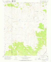
1966 Map of Fremont Pass
USGS Topo · Published 1968About this map
Fremont Pass serves as a central geographical marker within this mid-1960s survey, where the high-altitude terrain of the Iron and Garfield County line is defined by a network of drainage basins and ridges. The landscape is characterized by its reliance on isolated water sources such as Redcedar Spring, Coyote Lake, and Joes Pond. Human activity in this remote area is primarily represented by a series of primitive transport routes, including several Jeep Trails and unnamed Trails that connect the high valleys. A single Prospect in Granite Valley and a Radio Facility near the county line indicate sparse industrial and utility footprints. The map details the complex topography from the depths of Hawkins Canyon to the heights of Little Dog Valley Peak, illustrating a wilderness before modern development significantly altered these access paths.
Find a feature on this map
26 named features on this map. Tap any name to fly to it.
Don’t see what you’re looking for? This feature index may not catch every label — zoom into the map to look around manually.
Map Details
Editions of this 1966 Fremont Pass Map
2 editions found
Other maps of this area

1885 · Beaver
USGS Topo · 1:250,000

1886 · Kanab
USGS Topo · 1:250,000

1953 · Richfield
USGS Topo · 1:250,000

1953 · Cedar City
USGS Topo · 1:250,000

1958 · Richfield
USGS Topo · 1:250,000

1958 · Cedar City
USGS Topo · 1:250,000

1962 · Cedar City
USGS Topo · 1:250,000

1966 · Bull Rush Peak
USGS Topo · 1:24,000

1966 · Circleville
USGS Topo · 1:24,000

1966 · Panguitch NW
USGS Topo · 1:24,000