
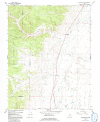
1966 Map of Panguitch NW
USGS Topo · Published 1969About this map
Bear Valley Junction serves as the primary waypoint in this mid-1960s landscape, where the rugged edge of the Dixie National Forest meets a complex network of agricultural irrigation. The hydrology of the region is defined by the Sevier River and an intricate system of man-made waterways, including the Panguitch Canal, La Fevre Canal, and the Old State Canal. These engineering efforts transformed the arid valley floor, supporting a series of local landmarks like the Marshall Ditch and Tebbs Hollow.
Find a feature on this map
31 named features on this map. Tap any name to fly to it.
Don’t see what you’re looking for? This feature index may not catch every label — zoom into the map to look around manually.
Map Details
Editions of this 1966 Panguitch NW Map
2 editions found
Other maps of this area

1885 · Beaver
USGS Topo · 1:250,000

1886 · Kanab
USGS Topo · 1:250,000

1953 · Richfield
USGS Topo · 1:250,000

1953 · Cedar City
USGS Topo · 1:250,000

1958 · Richfield
USGS Topo · 1:250,000

1958 · Cedar City
USGS Topo · 1:250,000

1962 · Cedar City
USGS Topo · 1:250,000

1966 · Bull Rush Peak
USGS Topo · 1:24,000

1966 · Fremont Pass
USGS Topo · 1:24,000
1971 · Burnt Peak
USGS Topo · 1:24,000