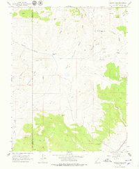
1966 Map of Fremont Pass
USGS Topo · Published 1979About this map
Fremont Pass serves as a high-altitude crossing point in this mid-1960s survey of the high plateau country along the boundary of Iron and Garfield Counties. The landscape is defined by its complex network of seasonal water sources and steep drainage systems, including Brady Creek and Echard Creek, which flow through the expansive Dog Valley. High-elevation infrastructure is limited, though the Radio Facility Bear stands prominently on a ridge in the southwestern portion of the sheet. Surveyors documented a remote wilderness environment where movement was largely restricted to a Jeep Trail or Pack Trail. Small alpine water bodies like Coyote Lake and Rock Pond are scattered among named features such as Boo Boy Hill and the Granite Knolls, suggesting a region primarily used for seasonal grazing or limited resource exploration, evidenced by a solitary Prospect near Granite Valley.
Find a feature on this map
46 named features on this map. Tap any name to fly to it.
Don’t see what you’re looking for? This feature index may not catch every label — zoom into the map to look around manually.
Map Details
Editions of this 1966 Fremont Pass Map
2 editions found
Other maps of this area

1885 · Beaver
USGS Topo · 1:250,000

1886 · Kanab
USGS Topo · 1:250,000

1953 · Richfield
USGS Topo · 1:250,000

1953 · Cedar City
USGS Topo · 1:250,000

1958 · Richfield
USGS Topo · 1:250,000

1958 · Cedar City
USGS Topo · 1:250,000

1962 · Cedar City
USGS Topo · 1:250,000

1966 · Bull Rush Peak
USGS Topo · 1:24,000

1966 · Circleville
USGS Topo · 1:24,000

1966 · Fremont Pass
USGS Topo · 1:24,000