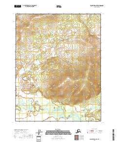
2018 Map of Black River C-2 SW
USGS Topo · Published 2018About this map
Salmon Fork Black River meanders across the southern landscape of this 2018 survey, carving a complex series of oxbows and gravel bars through the valley floor. The watercourse serves as the primary geographic focal point in an otherwise remote wilderness characterized by steep, ascending ridges and deep drainages. In the southeastern portion of the quadrangle, Bullhawk Cr flows north to join the main river system, cutting through the elevation contours that define the local topography. This map documents a pristine riverine environment in the Yukon-Koyukuk region, illustrating the natural drainage patterns and landforms as they existed in the early 21st century. The absence of roads or structures emphasizes the isolation of the area, where the river serves as the dominant feature for navigation and habitat.
Find a feature on this map
9 named features on this map. Tap any name to fly to it.
Don’t see what you’re looking for? This feature index may not catch every label — zoom into the map to look around manually.
Map Details
Editions of this 2018 Black River C-2 SW Map
This is the sole edition of this map. No revisions or reprints were ever made.
Other maps of this area

1951 · Black River
USGS Topo · 1:250,000

1956 · Black River B-3
USGS Topo · 1:63,360

1956 · Black River B-2
USGS Topo · 1:63,360

1956 · Black River C-2
USGS Topo · 1:63,360

1956 · Black River C-3
USGS Topo · 1:63,360

1956 · Black River
USGS Topo · 1:250,000

1964 · Black River
USGS Topo · 1:250,000
2018 · Black River C-3 NE
USGS Topo · 1:25,000
2018 · Black River B-2 NE
USGS Topo · 1:25,000
2018 · Black River B-3 NE
USGS Topo · 1:25,000