
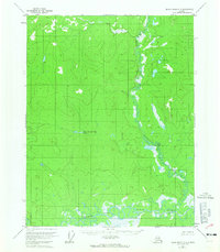
1956 Map of Black River C-3
USGS Topo · Published 1959About this map
The Salmon Fork Black River dominates the southern reaches of this interior Alaskan landscape, characterized by a complex network of meandering oxbows and marshy lowlands. To the north, the terrain rises into significant elevations drained by the winding Kevinjik Creek, which flows through a distinct valley before joining the larger river system. A single Cabin in the northwest corner represents the only named human structure, highlighting the extreme isolation of this subarctic region during the mid-1950s. The presence of Cow and Calf Moose Lake provides a specific landmark for navigators and hints at the local fauna that historically supported subsistence hunters and trappers in this roadless wilderness.
Find a feature on this map
4 named features on this map. Tap any name to fly to it.
Don’t see what you’re looking for? This feature index may not catch every label — zoom into the map to look around manually.
Map Details
Editions of this 1956 Black River C-3 Map
2 editions found
Other maps of this area

1951 · Black River
USGS Topo · 1:250,000

1956 · Black River D-3
USGS Topo · 1:63,360

1956 · Black River B-3
USGS Topo · 1:63,360

1956 · Black River B-2
USGS Topo · 1:63,360

1956 · Black River D-4
USGS Topo · 1:63,360

1956 · Black River B-4
USGS Topo · 1:63,360

1956 · Black River C-2
USGS Topo · 1:63,360

1956 · Black River D-2
USGS Topo · 1:63,360

1956 · Black River C-4
USGS Topo · 1:63,360

1956 · Black River
USGS Topo · 1:250,000