
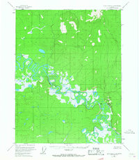
1956 Map of Black River C-4
USGS Topo · Published 1959About this map
The Black River meanders through this remote interior landscape, creating an intricate network of oxbows and wetlands during the mid-1950s. The river's path is defined by sharp geographical markers like Nelson Bluff and the prominent heights of Niggerhead Mountain and Vadahanyande Mountain. This topographic study, based on 1955 aerial photography, reveals a wilderness where life centered on the water. Human presence is concentrated at Salmon Village, located near the confluence of the river and the Salmon Fork. The map documents a traditional subsistence landscape, naming local water features like Rotten Fish Slough and Tienasheadun Slough, which were essential for navigation and seasonal movement. An isolated Cabin near Nelson Lake further indicates the sparse, resource-driven settlement pattern of the era.
Find a feature on this map
10 named features on this map. Tap any name to fly to it.
Don’t see what you’re looking for? This feature index may not catch every label — zoom into the map to look around manually.
Map Details
Editions of this 1956 Black River C-4 Map
2 editions found
Other maps of this area

1951 · Black River
USGS Topo · 1:250,000

1956 · Black River D-3
USGS Topo · 1:63,360

1956 · Black River B-5
USGS Topo · 1:63,360

1956 · Black River B-3
USGS Topo · 1:63,360

1956 · Black River D-4
USGS Topo · 1:63,360

1956 · Black River D-5
USGS Topo · 1:63,360

1956 · Black River B-4
USGS Topo · 1:63,360

1956 · Black River C-5
USGS Topo · 1:63,360

1956 · Black River C-3
USGS Topo · 1:63,360

1956 · Black River
USGS Topo · 1:250,000