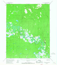
1956 Map of Black River C-4
USGS Topo · Published 1967About this map
Black River meanders across this mid-century sub-arctic landscape, carving a complex network of waterways including Rotten Fish Slough and Tienasheun Slough. The terrain is defined by the sharp rise of Nelson Bluff and the prominent Vacahanyande Mountain, which stand in contrast to the surrounding marshy lowlands and oxbow lakes like Nelson Lake. Evidence of localized settlement and seasonal camps is concentrated near the water, notably at Salmon Village and Old Salmon Village situated near the confluence of the Salmon Fork. A solitary Cabin appears on the western edge, suggesting the isolation of the area during the 1950s. The dense concentration of sloughs and interconnected river channels implies a landscape where travel and subsistence were dictated by the seasonal flow of the river system rather than overland routes.
Find a feature on this map
15 named features on this map. Tap any name to fly to it.
Don’t see what you’re looking for? This feature index may not catch every label — zoom into the map to look around manually.
Map Details
Editions of this 1956 Black River C-4 Map
2 editions found
Other maps of this area

1951 · Black River
USGS Topo · 1:250,000

1956 · Black River D-3
USGS Topo · 1:63,360

1956 · Black River B-5
USGS Topo · 1:63,360

1956 · Black River B-3
USGS Topo · 1:63,360

1956 · Black River D-4
USGS Topo · 1:63,360

1956 · Black River D-5
USGS Topo · 1:63,360

1956 · Black River B-4
USGS Topo · 1:63,360

1956 · Black River C-5
USGS Topo · 1:63,360

1956 · Black River C-4
USGS Topo · 1:63,360

1956 · Black River C-3
USGS Topo · 1:63,360