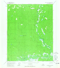
1956 Map of Black River C-3
USGS Topo · Published 1965About this map
Salmon Fork Black River snakes through the southern reaches of this landscape, its complex oxbows and marshy banks dominating the lower terrain. This 1950s aerial survey captures a remote interior wilderness where the primary landmark for navigation is the winding course of Kevinjik Creek, which drains southward through a series of interconnected wetlands. A lone Cabin in the northwest stands as one of the few human imprints in a territory defined by intricate water systems, including the uniquely named Cow and Calf Moose Lake. The map reveals a land before permanent modern development, where survey lines established by the Bureau of Land Management remain largely unsurveyed and unmarked on the ground, leaving the drainage patterns of the Salmon Fork as the definitive features of the regional geography.
Find a feature on this map
10 named features on this map. Tap any name to fly to it.
Don’t see what you’re looking for? This feature index may not catch every label — zoom into the map to look around manually.
Map Details
Editions of this 1956 Black River C-3 Map
2 editions found
Other maps of this area

1951 · Black River
USGS Topo · 1:250,000

1956 · Black River D-3
USGS Topo · 1:63,360

1956 · Black River B-3
USGS Topo · 1:63,360

1956 · Black River B-2
USGS Topo · 1:63,360

1956 · Black River D-4
USGS Topo · 1:63,360

1956 · Black River B-4
USGS Topo · 1:63,360

1956 · Black River C-2
USGS Topo · 1:63,360

1956 · Black River D-2
USGS Topo · 1:63,360

1956 · Black River C-4
USGS Topo · 1:63,360

1956 · Black River C-3
USGS Topo · 1:63,360