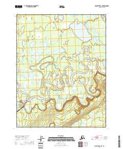
2018 Map of Black River C-6 NE
USGS Topo · Published 2018About this map
Draanjik River meanders across this subarctic landscape, carving a complex series of oxbow lakes and wetlands that define the Yukon-Koyukuk region. In the northern reaches, Chahalie Lake and a dense network of smaller unnamed water bodies are drained by Fishhook Creek, illustrating the intricate drainage patterns of the Alaskan interior. The terrain rises to the south at Tsoktul Hill, overlooking a small pocket of infrastructure near the village of Chalkyitsik. Here, the Chalkyitsik Airport and a modest network of local routes including Boundary Road, Kutchin Street, and Gravel Pit Road mark the human footprint. The survey also records the prominent elevation of Red Bluff along the eastern riverbank, providing a clear picture of the topography before these remote waterways shift their channels over time.
Find a feature on this map
17 named features on this map. Tap any name to fly to it.
Don’t see what you’re looking for? This feature index may not catch every label — zoom into the map to look around manually.
Map Details
Editions of this 2018 Black River C-6 NE Map
This is the sole edition of this map. No revisions or reprints were ever made.
Other maps of this area

1951 · Black River
USGS Topo · 1:250,000

1956 · Black River D-6
USGS Topo · 1:63,360

1956 · Black River D-5
USGS Topo · 1:63,360

1956 · Black River C-6
USGS Topo · 1:63,360

1956 · Black River C-5
USGS Topo · 1:63,360

1956 · Black River
USGS Topo · 1:250,000

1964 · Black River
USGS Topo · 1:250,000
2018 · Black River C-6 SE
USGS Topo · 1:25,000
2018 · Black River D-6 SE
USGS Topo · 1:25,000
2018 · Black River C-5 SW
USGS Topo · 1:25,000