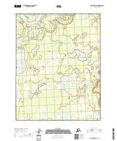
2018 Map of Black River D-6 SE
USGS Topo · Published 2018About this map
The Porcupine River sweeps through the northern reaches of this Yukon-Koyukuk interior landscape, defining a complex hydrography of shifting channels and low-lying basins. The terrain is characterized by a dense network of water bodies, where the Black River Slough and various isolated basins like Schrader Lake and Rock Lake illustrate the seasonal pulse of an Arctic river system. Further east, a cluster of named water features including Willow Lake, Mud Lake, Cabin Lake, and Scotty Lake suggests a localized drainage pattern typical of the region's wetland environment. This 2018 survey by the U.S. Geological Survey documents the unpopulated wilderness near the Canadian border, where the absence of roads and human structures highlights a landscape shaped entirely by natural alluvial processes and permafrost hydrology.
Find a feature on this map
15 named features on this map. Tap any name to fly to it.
Don’t see what you’re looking for? This feature index may not catch every label — zoom into the map to look around manually.
Map Details
Editions of this 2018 Black River D-6 SE Map
This is the sole edition of this map. No revisions or reprints were ever made.
Other maps of this area

1951 · Black River
USGS Topo · 1:250,000

1956 · Black River D-6
USGS Topo · 1:63,360

1956 · Black River D-5
USGS Topo · 1:63,360

1956 · Black River C-6
USGS Topo · 1:63,360

1956 · Black River C-5
USGS Topo · 1:63,360

1956 · Black River
USGS Topo · 1:250,000

1964 · Black River
USGS Topo · 1:250,000
2018 · Black River D-6 NW
USGS Topo · 1:25,000
2018 · Black River D-5 NW
USGS Topo · 1:25,000
2018 · Black River C-5 NW
USGS Topo · 1:25,000