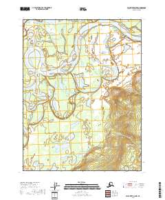
2018 Map of Black River D-5 NW
USGS Topo · Published 2018About this map
Porcupine River dominates this northern Alaskan landscape, winding through a complex network of wetlands and shifting channels. The terrain here is defined by low-lying hydrologic features including Rock Slough in the northwest and Henderson Slough to the south. This area, part of the Yukon-Koyukuk Census Area, illustrates the dynamic nature of arctic river systems where water bodies frequently meander and reorganize across the tundra. One of the few named topographic elevations in this reach is Graphite Point, situated on a bend in the river near the northeastern corner. The map provides an exacting record of the surface water and wetland classifications as they existed in the early 21st century, offering a baseline for studying the remote interior of the state.
Find a feature on this map
8 named features on this map. Tap any name to fly to it.
Don’t see what you’re looking for? This feature index may not catch every label — zoom into the map to look around manually.
Map Details
Editions of this 2018 Black River D-5 NW Map
This is the sole edition of this map. No revisions or reprints were ever made.
Other maps of this area

1951 · Black River
USGS Topo · 1:250,000

1951 · Coleen
USGS Topo · 1:250,000

1956 · Coleen
USGS Topo · 1:250,000

1956 · Black River D-6
USGS Topo · 1:63,360

1956 · Coleen A-5
USGS Topo · 1:63,360

1956 · Black River D-5
USGS Topo · 1:63,360
1956 · Coleen A-6
USGS Topo · 1:63,360

1956 · Black River
USGS Topo · 1:250,000

1964 · Black River
USGS Topo · 1:250,000
2018 · Coleen A-5 SW
USGS Topo · 1:25,000