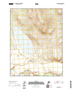
2018 Map of Coleen A-5 SW
USGS Topo · Published 2018About this map
Graphite Lake defines the central geography of this remote landscape in the Yukon-Koyukuk region. The water body is the primary named feature amidst a vast network of wetlands and varying elevations, surveyed as part of the public land survey system including t26n r19e and t26n r20e. The terrain transitions from high ridges to low-lying basins, illustrating the unpopulated interior of northern Alaska. Without roads or permanent settlements recorded on this sheet, the focus remains on the natural topography and the legal boundaries of the various townships, such as t25n r20e and t27n r20e, which define this portion of the Coleen A-5 SW quadrangle.
Find a feature on this map
7 named features on this map. Tap any name to fly to it.
Don’t see what you’re looking for? This feature index may not catch every label — zoom into the map to look around manually.
Map Details
Editions of this 2018 Coleen A-5 SW Map
This is the sole edition of this map. No revisions or reprints were ever made.
Other maps of this area

1951 · Black River
USGS Topo · 1:250,000

1951 · Coleen
USGS Topo · 1:250,000

1956 · Coleen
USGS Topo · 1:250,000

1956 · Black River D-6
USGS Topo · 1:63,360

1956 · Coleen A-5
USGS Topo · 1:63,360

1956 · Black River D-5
USGS Topo · 1:63,360
1956 · Coleen A-6
USGS Topo · 1:63,360

1956 · Black River
USGS Topo · 1:250,000

1964 · Black River
USGS Topo · 1:250,000
2018 · Coleen A-5 NW
USGS Topo · 1:25,000