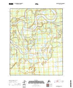
2018 Map of Black River D-6 SW
USGS Topo · Published 2018About this map
The Porcupine River dominates this landscape of the Yukon-Koyukuk Census Area, winding through a complex network of wetlands and seasonal waterways. The hydrological pattern is defined by dramatic river meanders and long, curving channels such as Ninemile Slough and Sixmile Slough, which illustrate the shifting nature of the arctic river system. Smaller water bodies like Loon Lake and the various branches of the Black River Slough are scattered throughout the low-lying terrain, highlighting a wilderness area shaped entirely by water movement rather than permanent human settlements. This 2018 survey serves as a vital record of the braided river morphology and the extensive wetland environments that characterize this portion of the Alaska interior.
Find a feature on this map
13 named features on this map. Tap any name to fly to it.
Don’t see what you’re looking for? This feature index may not catch every label — zoom into the map to look around manually.
Map Details
Editions of this 2018 Black River D-6 SW Map
This is the sole edition of this map. No revisions or reprints were ever made.
Other maps of this area

1951 · Fort Yukon
USGS Topo · 1:250,000

1951 · Black River
USGS Topo · 1:250,000

1956 · Fort Yukon C-1
USGS Topo · 1:63,360

1956 · Black River D-6
USGS Topo · 1:63,360

1956 · Black River C-6
USGS Topo · 1:63,360
1956 · Fort Yukon D-1
USGS Topo · 1:63,360

1956 · Fort Yukon
USGS Topo · 1:250,000

1956 · Black River
USGS Topo · 1:250,000

1964 · Black River
USGS Topo · 1:250,000
2018 · Black River D-6 NW
USGS Topo · 1:25,000