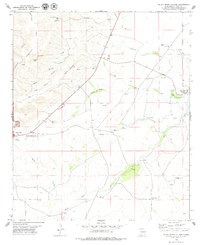
1979 Map of Black River Village
USGS Topo · Published 1979About this map
Guadalupe Ridge dominates the western topography of this landscape where the desert floor meets the rising limestone uplands of southeast New Mexico. The map records the interface between the protected wilderness of Carlsbad Caverns National Park and the industrial activity of the surrounding flats, marked by numerous Gas Wells and Drill Holes. Water management is central to life here, evidenced by named sources like Box Spring, Jurnigan Spring, and Blue Spring which feed into the Black River.
Find a feature on this map
28 named features on this map. Tap any name to fly to it.
Don’t see what you’re looking for? This feature index may not catch every label — zoom into the map to look around manually.
Map Details
Editions of this 1979 Black River Village Map
This is the sole edition of this map. No revisions or reprints were ever made.
Other maps of this area

1939 · Carlsbad
USGS Topo · 1:62,500

1943 · Carlsbad
USGS Topo · 1:62,500

1943 · West Carlsbad
USGS Topo · 1:62,500

1945 · West Carlsbad
USGS Topo · 1:62,500

1945 · Carlsbad Caverns East
USGS Topo · 1:62,500

1945 · Malaga
USGS Topo · 1:62,500

1946 · Malaga
USGS Topo · 1:62,500

1947 · Carlsbad Caverns East
USGS Topo · 1:62,500

1954 · Carlsbad
USGS Topo · 1:250,000

1958 · Carlsbad
USGS Topo · 1:250,000