1953 Map of Black Rock Spring NE
USGS Topo · Published 1957About this map
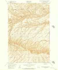
Yakima Firing Center Military Reservation dominates this 1953 survey, illustrating a landscape primarily dedicated to military training and open rangeland. The topography is defined by the significant rise of Umtanum Ridge, which separates the high desert plains from the complex drainage systems to the north and east. Sparse evidence of permanent human settlement is visible, with only the Stewart Ranch appearing in the center of the sheet, providing a rare genealogical marker for family researchers in this part of Washington. The rugged geography is further detailed by deep seasonal cuts like Alkali Canyon and Corral Canyon. These natural features, along with Sourdough Canyon and Cow Canyon, highlight the drainage patterns through the high country where the border between Kittitas and Yakima Counties is established.
Find a feature on this map
8 named features on this map. Tap any name to fly to it.
Don’t see what you’re looking for? This feature index may not catch every label — zoom into the map to look around manually.
Map Details
Editions of this 1953 Black Rock Spring NE Map
2 editions found
Historical Maps of Yakima County Through Time
188 maps found

1902 Mount Aix
Yakima County, WA

1904 Mount Adams
Yakima County, WA

1904 Mount Aix
Yakima County, WA

1907 Mount Adams
Yakima County, WA

1936 Hog Ranch Buttes
Yakima County, WA

1936 Yakima East
Yakima County, WA

1941 Black Rock Spring
Yakima County, WA

1941 Yakima East
Yakima County, WA

1948 Cairn Hope Peak
Yakima County, WA

1953 Black Rock Spring NE
Yakima County, WA

1953 Black Rock Spring NW
Yakima County, WA

1953 Black Rock Spring SW
Yakima County, WA

1953 Black Rock Spring
Yakima County, WA

1953 Black Rock Spring
Yakima County, WA

1953 Elephant Mountain
Yakima County, WA

1953 Pomona
Yakima County, WA

1953 Selah Springs
Yakima County, WA

1953 Yakima East
Yakima County, WA

1953 Yakima East
Yakima County, WA

1955 Prosser SW
Yakima County, WA

1957 Willy Dick Canyon
Yakima County, WA

1957 Yesmowit Canyon
Yakima County, WA

1958 Fort Simcoe
Yakima County, WA

1958 Fort Simcoe
Yakima County, WA

1958 Harrah SE
Yakima County, WA

1958 Hembre Mtn
Yakima County, WA

1958 Medicine Valley
Yakima County, WA

1958 Toppenish Mtn.
Yakima County, WA

1958 Toppenish SW
Yakima County, WA

1958 Wiley City
Yakima County, WA

1958 Yakima West
Yakima County, WA

1962 Bumping Lake
Yakima County, WA

1962 White Pass
Yakima County, WA

1964 Granger NE
Yakima County, WA

1965 Bluelight NW
Yakima County, WA

1965 Bluelight
Yakima County, WA

1965 Bluelight
Yakima County, WA

1965 Camas Patch
Yakima County, WA

1965 Granger NW
Yakima County, WA

1965 Hagerty Butte
Yakima County, WA

1965 Kusshi Creek
Yakima County, WA

1965 Logy Creek Falls
Yakima County, WA

1965 Logy Creek NE
Yakima County, WA

1965 Logy Creek SW
Yakima County, WA

1965 Logy Creek
Yakima County, WA

1965 Mabton East
Yakima County, WA

1965 Mabton West
Yakima County, WA

1965 Mc Kays Butte
Yakima County, WA

1965 Poisel Butte NW
Yakima County, WA

1965 Poisel Butte SE
Yakima County, WA

1965 Poisel Butte SW
Yakima County, WA

1965 Poisel Butte
Yakima County, WA

1965 Poisel Butte
Yakima County, WA

1965 Prosser SW
Yakima County, WA

1965 Stagman Butte
Yakima County, WA

1965 Tule Prong
Yakima County, WA

1967 Darland Mtn
Yakima County, WA

1967 Foundation Ridge
Yakima County, WA

1967 Rimrock Lake
Yakima County, WA

1967 Tieton Basin
Yakima County, WA

1968 Twin Buttes
Yakima County, WA

1969 Castile Falls
Yakima County, WA

1970 Castile Falls
Yakima County, WA

1970 Fairview Ridge
Yakima County, WA

1970 Glaciate Butte
Yakima County, WA

1970 Jennies Butte
Yakima County, WA

1970 Jungle Butte
Yakima County, WA

1970 Lost Horse Plateau
Yakima County, WA

1970 Mount Adams East
Yakima County, WA

1970 Outlet Falls
Yakima County, WA

1970 Piscoe Meadow
Yakima County, WA

1970 Poland Butte
Yakima County, WA

1970 Signal Peak
Yakima County, WA

1970 Windy Point
Yakima County, WA

1971 King Mountain
Yakima County, WA

1971 Meeks Table
Yakima County, WA

1971 Milk Canyon
Yakima County, WA

1971 Old Scab Mtn.
Yakima County, WA

1971 Pine Mtn.
Yakima County, WA

1971 Timberwolf Mtn.
Yakima County, WA

1971 Weddle Canyon
Yakima County, WA

1978 Mount Rainier
Yakima County, WA

1978 Sulphur Spring
Yakima County, WA

1984 The Cottonwoods
Yakima County, WA

1985 Wenas Lake
Yakima County, WA

1988 Bumping Lake
Yakima County, WA

1988 Cougar Lake
Yakima County, WA

1988 Goose Prairie
Yakima County, WA

1988 Norse Peak
Yakima County, WA

1988 Pinegrass Ridge
Yakima County, WA

1988 Spiral Butte
Yakima County, WA

1989 Raven Roost
Yakima County, WA

1992 Meeks Table
Yakima County, WA

1992 Old Scab Mtn
Yakima County, WA

1992 Rimrock Lake
Yakima County, WA

1992 Tieton Basin
Yakima County, WA

1998 Glaciate Butte
Yakima County, WA

1998 King Mountain
Yakima County, WA

1998 Mount Adams East
Yakima County, WA

2000 Bumping Lake
Yakima County, WA

2000 Cougar Lake
Yakima County, WA

2000 Darland Mountain
Yakima County, WA

2000 Fairview Ridge
Yakima County, WA

2000 Foundation Ridge
Yakima County, WA

2000 Goose Prairie
Yakima County, WA

2000 Jennies Butte
Yakima County, WA

2000 Meeks Table
Yakima County, WA

2000 Norse Peak
Yakima County, WA

2000 Old Scab Mountain
Yakima County, WA

2000 Pinegrass Ridge
Yakima County, WA

2000 Rimrock Lake
Yakima County, WA

2000 Spiral Butte
Yakima County, WA

2000 Tieton Basin
Yakima County, WA

2000 Timberwolf Mountain
Yakima County, WA

2000 Weddle Canyon
Yakima County, WA

2023 Black Rock Spring NE
Yakima County, WA

2023 Black Rock Spring NW
Yakima County, WA

2023 Black Rock Spring SW
Yakima County, WA

2023 Black Rock Spring
Yakima County, WA

2023 Bluelight NW
Yakima County, WA

2023 Bluelight
Yakima County, WA

2023 Bumping Lake
Yakima County, WA

2023 Cairn Hope Peak
Yakima County, WA

2023 Camas Patch
Yakima County, WA

2023 Castile Falls
Yakima County, WA

2023 Cougar Lake
Yakima County, WA

2023 Darland Mountain
Yakima County, WA

2023 Elephant Mountain
Yakima County, WA

2023 Fairview Ridge
Yakima County, WA

2023 Fort Simcoe
Yakima County, WA

2023 Foundation Ridge
Yakima County, WA

2023 Glaciate Butte
Yakima County, WA

2023 Goose Prairie
Yakima County, WA

2023 Granger NE
Yakima County, WA

2023 Granger NW
Yakima County, WA

2023 Hagerty Butte
Yakima County, WA

2023 Harrah SE
Yakima County, WA

2023 Jennies Butte
Yakima County, WA

2023 Jungle Butte
Yakima County, WA

2023 King Mountain
Yakima County, WA

2023 Kisumxi Mountain
Yakima County, WA

2023 Kusshi Creek
Yakima County, WA

2023 Logy Creek Falls
Yakima County, WA

2023 Logy Creek NE
Yakima County, WA

2023 Logy Creek SW
Yakima County, WA

2023 Lost Horse Plateau
Yakima County, WA

2023 Mabton East
Yakima County, WA

2023 Mabton West
Yakima County, WA

2023 McKays Butte
Yakima County, WA

2023 Medicine Valley
Yakima County, WA

2023 Meeks Table
Yakima County, WA

2023 Milk Canyon
Yakima County, WA

2023 Mount Adams East
Yakima County, WA

2023 Norse Peak
Yakima County, WA

2023 Old Scab Mountain
Yakima County, WA

2023 Outlet Falls
Yakima County, WA

2023 Pinegrass Ridge
Yakima County, WA

2023 Pine Mountain
Yakima County, WA

2023 Piscoe Meadow
Yakima County, WA

2023 Poisel Butte NW
Yakima County, WA

2023 Poisel Butte SE
Yakima County, WA

2023 Poisel Butte SW
Yakima County, WA

2023 Poisel Butte
Yakima County, WA

2023 Poland Butte
Yakima County, WA

2023 Pomona
Yakima County, WA

2023 Prosser SW
Yakima County, WA

2023 Raven Roost
Yakima County, WA

2023 Rimrock Lake
Yakima County, WA

2023 Selah Springs
Yakima County, WA

2023 Signal Peak
Yakima County, WA

2023 Spiral Butte
Yakima County, WA

2023 Stagman Butte
Yakima County, WA

2023 Sulphur Spring
Yakima County, WA

2023 The Cottonwoods
Yakima County, WA

2023 Tieton Basin
Yakima County, WA

2023 Timberwolf Mountain
Yakima County, WA

2023 Toppenish Mountain
Yakima County, WA

2023 Toppenish SW
Yakima County, WA

2023 Tule Prong
Yakima County, WA

2023 Twin Buttes
Yakima County, WA

2023 Weddle Canyon
Yakima County, WA

2023 Wenas Lake
Yakima County, WA

2023 Wiley City
Yakima County, WA

2023 Willy Dick Canyon
Yakima County, WA

2023 Windy Point
Yakima County, WA

2023 Yakima East
Yakima County, WA

2023 Yakima West
Yakima County, WA

2023 Yesmowit Canyon
Yakima County, WA