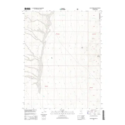
2014 Map of Black Spring NW
USGS Topo · Published 2014About this map
Ione Valley provides a striking example of the Great Basin's drainage patterns in the early 21st century. The landscape is dominated by the massive alluvial fan of Ione Wash, which spreads across the western half of the map, illustrating the high-energy sediment transport typical of this arid region. To the east, the terrain rises sharply into the Shoshone Mountains, where deep drainages like Indian Canyon and Cottonwood Creek cut through the high ground. A significant portion of this eastern highland is protected within the Toiyabe Nat For, highlighting the intersection of public land management and the topographical divide between the valley floor and the wooded mountain ranges. The map also delineates township and range boundaries including t10n r38e and t9n r39e, providing essential reference points for researchers tracking land patents and historical surveys in Nye County.
Find a feature on this map
10 named features on this map. Tap any name to fly to it.
Don’t see what you’re looking for? This feature index may not catch every label — zoom into the map to look around manually.
Map Details
Editions of this 2014 Black Spring NW Map
This is the sole edition of this map. No revisions or reprints were ever made.
Other maps of this area

1907 · Tonopah
USGS Topo · 1:250,000

1908 · Tonopah
USGS Topo · 1:250,000

1948 · Paradise Peak
USGS Topo · 1:62,500

1948 · Ione
USGS Topo · 1:62,500

1950 · Paradise Peak
USGS Topo · 1:62,500

1950 · Ione
USGS Topo · 1:62,500

1956 · Tonopah
USGS Topo · 1:250,000

1959 · Tonopah
USGS Topo · 1:250,000

1962 · Tonopah
USGS Topo · 1:250,000
1979 · Goldyke
USGS Topo · 1:24,000