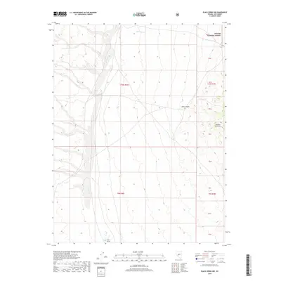
2018 Map of Black Spring NW
USGS Topo · Published 2018About this map
Ione Valley dominates this high-desert basin in Nye County, showing a landscape defined by seasonal watercourses and the stark rise of the Shoshone Mountains to the east. At the northern edge of the valley, the drainages of Ione Wash and Cottonwood Cr illustrate the drainage patterns typical of this portion of the Great Basin. The northeastern corner of the map covers a section of the Toiyabe National Forest, where the terrain transitions into the steep elevations of Indian Canyon. Evidence of land use is centered around the Cloverdale Ranch area, reflecting the long-standing ranching traditions in this part of Nevada. This 2018 survey provides an exact look at the property lines and natural landmarks within the township and range grids of T10N R38E and T9N R38E.
Find a feature on this map
11 named features on this map. Tap any name to fly to it.
Don’t see what you’re looking for? This feature index may not catch every label — zoom into the map to look around manually.
Map Details
Editions of this 2018 Black Spring NW Map
This is the sole edition of this map. No revisions or reprints were ever made.
Other maps of this area

1907 · Tonopah
USGS Topo · 1:250,000

1908 · Tonopah
USGS Topo · 1:250,000

1948 · Paradise Peak
USGS Topo · 1:62,500

1948 · Ione
USGS Topo · 1:62,500

1950 · Paradise Peak
USGS Topo · 1:62,500

1950 · Ione
USGS Topo · 1:62,500

1956 · Tonopah
USGS Topo · 1:250,000

1959 · Tonopah
USGS Topo · 1:250,000

1962 · Tonopah
USGS Topo · 1:250,000
1979 · Goldyke
USGS Topo · 1:24,000