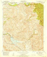
1950 Map of Black Star Canyon
USGS Topo · Published 1950About this map
Irvine Lake and the Santiago de Santa Ana mountains dominate this 1950 topographical study, revealing the industrial and water-management landscape of eastern Orange County just after World War II. The map identifies the Santiago Dam and a series of significant canyons including Black Star Canyon, Fremont Canyon, and Gypsum Canyon. A distinct history of resource extraction is evident through the labeling of the Santiago Coal Mine (Inactive) and the Black Star Coal Mine (Inactive), both marked as inactive by this date. To the north, the Santa Ana River flows through the Santa Ana Canyon, supported by infrastructure like the Diversion Dam, Anaheim Canal, and Santa Ana Canal. This area reflects a mid-century period where recreation at Irvine Park and the preservation of the Cleveland National Forest balanced against the region's mining and hydraulic history.
Find a feature on this map
41 named features on this map. Tap any name to fly to it.
Don’t see what you’re looking for? This feature index may not catch every label — zoom into the map to look around manually.
Map Details
Editions of this 1950 Black Star Canyon Map
This is the sole edition of this map. No revisions or reprints were ever made.
Other maps of this area

1896 · Santa Ana
USGS Topo · 1:62,500

1896 · Anaheim
USGS Topo · 1:62,500

1898 · Anaheim
USGS Topo · 1:62,500

1901 · Southern California Sheet No. 1
USGS Topo · 1:250,000

1901 · Santa Ana
USGS Topo · 1:62,500

1901 · Anaheim
USGS Topo · 1:62,500

1902 · Corona
USGS Topo · 1:125,000

1904 · Southern California Sheet No. 1
USGS Topo · 1:250,000

1932 · Orange
USGS Topo · 1:31,680

1932 · Tustin
USGS Topo · 1:31,680