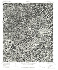
1974 Map of Black Star Canyon
USGS Topo · Published 1977About this map
The Santa Ana Mountains dominate this 1974 orthophotoquad, showing the intricate network of ridges and canyons before significant modern development reached this part of the range. This aerial perspective, captured by the Geological Survey in cooperation with the Orange County Board of Supervisors, reveals the raw geography of the Santiago Reservoir and the winding course of the Santa Ana River along the northern edge. The orthophoto format provides a unique visual record of the land surface, illustrating the contrast between the steep, brush-covered slopes and the relatively undeveloped alluvial flats of the day. It captures a moment in the mid-1970s when much of this rugged landscape remained in its natural state, providing an essential reference for understanding the historical topography of the canyon country before urban expansion altered the surrounding valleys.
Find a feature on this map
3 named features on this map. Tap any name to fly to it.
Don’t see what you’re looking for? This feature index may not catch every label — zoom into the map to look around manually.
Map Details
Editions of this 1974 Black Star Canyon Map
This is the sole edition of this map. No revisions or reprints were ever made.
Other maps of this area

1896 · Santa Ana
USGS Topo · 1:62,500

1896 · Anaheim
USGS Topo · 1:62,500

1898 · Anaheim
USGS Topo · 1:62,500

1901 · Southern California Sheet No. 1
USGS Topo · 1:250,000

1901 · Santa Ana
USGS Topo · 1:62,500

1901 · Anaheim
USGS Topo · 1:62,500

1902 · Corona
USGS Topo · 1:125,000

1904 · Southern California Sheet No. 1
USGS Topo · 1:250,000

1932 · Orange
USGS Topo · 1:31,680

1932 · Tustin
USGS Topo · 1:31,680