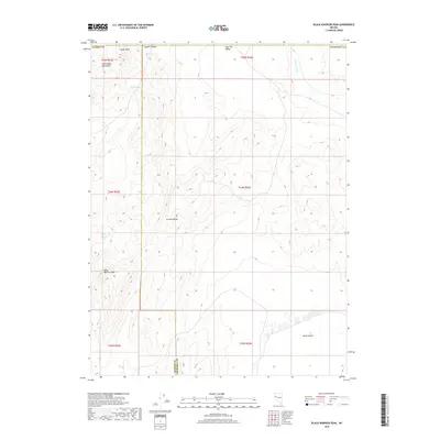
2018 Map of Black Warrior Peak
USGS Topo · Published 2018About this map
Black Warrior Peak dominates this high-desert landscape where the Truckee Range meets the Nightingale Mountains. The boundary between Washoe County and Churchill County cuts vertically through the high country, marking a transition between several distinct geological features. To the north, the terrain drops into Coyote Canyon and Sage Hen Valley, while the southern reaches of the map open into North Valley. This 2018 survey reveals the sparse, water-dependent geography of the Great Basin, where life and travel are defined by rare water sources like Black Warrior Spring and Coyote Spring. The drainage patterns are clearly mapped along Sage Hen Wash, illustrating how seasonal runoff shapes the arid basin-and-range topography. The presence of Nache Peak in the northwestern corner provides a secondary landmark for those navigating this unpopulated stretch of the Nevada desert.
Find a feature on this map
19 named features on this map. Tap any name to fly to it.
Don’t see what you’re looking for? This feature index may not catch every label — zoom into the map to look around manually.
Map Details
Editions of this 2018 Black Warrior Peak Map
This is the sole edition of this map. No revisions or reprints were ever made.
Other maps of this area

1886 · Granite Range
USGS Topo · 1:250,000

1890 · Wadsworth
USGS Topo · 1:125,000

1892 · Wadsworth
USGS Topo · 1:125,000

1894 · Granite Range
USGS Topo · 1:250,000

1894 · Wadsworth
USGS Topo · 1:125,000

1955 · Lovelock
USGS Topo · 1:250,000

1957 · Fireball Ridge
USGS Topo · 1:62,500

1957 · Nixon
USGS Topo · 1:62,500

1957 · Reno
USGS Topo · 1:250,000

1959 · Lovelock
USGS Topo · 1:250,000