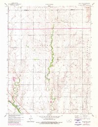
1957 Map of Black Wolf
USGS Topo · Published 1980About this map
Smoky Hill River flows through the southern portion of this Ellsworth County landscape, anchored by the small settlement of Black Wolf situated along the Union Pacific railroad line. The map reveals a rural expanse defined by major drainage systems, including Cow Creek and Buffalo Creek, which carve through the terrain as they move toward the river valley. Local life in the mid-20th century is marked by scattered spiritual and community landmarks like Excelsior Ch and the Pleasant Valley Cem. The upland areas are divided into historical townships such as Columbia, Sherman, and Black Wolf, while the northern border captures the line between Lincoln and Ellsworth counties. The arrival of modern infrastructure is evident in the path of highway 70 crossing the northern half of the sheet, signaling the transition from local rural roads to the interstate era.
Find a feature on this map
16 named features on this map. Tap any name to fly to it.
Don’t see what you’re looking for? This feature index may not catch every label — zoom into the map to look around manually.
Map Details
Editions of this 1957 Black Wolf Map
2 editions found
Other maps of this area

1894 · Ellsworth
USGS Topo · 1:125,000

1955 · Great Bend
USGS Topo · 1:250,000

1956 · Wilson
USGS Topo · 1:24,000

1957 · Great Bend
USGS Topo · 1:250,000

1957 · Ellsworth
USGS Topo · 1:24,000

1957 · Westfall SW
USGS Topo · 1:24,000

1957 · Holyrood NE
USGS Topo · 1:24,000

1957 · Black Wolf
USGS Topo · 1:24,000

1958 · Great Bend
USGS Topo · 1:250,000
1964 · Wilson NW
USGS Topo · 1:24,000