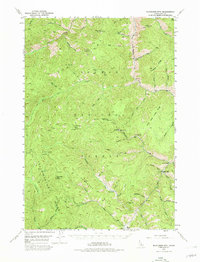
1950 Map of Blackbird Mtn
USGS Topo · Published 1980About this map
Mining and ranching activity define this mid-century survey of the high Salmon River country. The local economy is anchored by the Blackbird Mine and the settlement of Cobalt in the southern portion of the map, alongside several non-operational sites like the Sunshine Mine and Cobalt Mine. These industrial nodes are set against a landscape of high ridges, including Trapper Ridge and Little Deer Creek Ridge, where small clearings like Fritzer Flat and Trapper Flat provided level ground amidst the steep drainage basins.
Find a feature on this map
55 named features on this map. Tap any name to fly to it.
Don’t see what you’re looking for? This feature index may not catch every label — zoom into the map to look around manually.
Map Details
Editions of this 1950 Blackbird Mtn Map
3 editions found
Other maps of this area

1930 · Casto
USGS Topo · 1:125,000

1950 · Blackbird Mtn
USGS Topo · 1:62,500

1950 · Leesburg
USGS Topo · 1:62,500

1951 · Leesburg
USGS Topo · 1:62,500

1951 · Blackbird Mtn
USGS Topo · 1:62,500

1956 · Elk City
USGS Topo · 1:250,000

1957 · Challis
USGS Topo · 1:250,000

1960 · Elk City
USGS Topo · 1:250,000

1960 · Challis
USGS Topo · 1:250,000

1960 · Ulysses Mtn
USGS Topo · 1:62,500