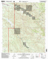
1996 Map of Blackburn Canyon
USGS Topo · Published 1999About this map
Cranston sits at the confluence of the San Jacinto River and its northern fork, marking a focal point where water and early transportation routes converge in the San Jacinto Mountains. The landscape is defined by the steep elevation changes between Blackburn Ridge and Rouse Ridge, punctuated by seasonal springs like Alvin Spring and the aptly named Halfway Spring. This terrain reflects the complex management of public and private interests in the late twentieth century, showing the boundaries of the San Bernardino National Forest alongside the San Jacinto Viejo Grant and the San Jacinto Game Refuge. A Gaging Station on the river and a Communication Facility atop Red Mountain underscore the technical infrastructure necessary for monitoring and maintaining this drainage basin. The map traces the winding paths of the Toll Road and Rouse Hill Road, providing a detailed look at the access points used by foresters and early travelers through Bautista Canyon.
Find a feature on this map
39 named features on this map. Tap any name to fly to it.
Don’t see what you’re looking for? This feature index may not catch every label — zoom into the map to look around manually.
Map Details
Editions of this 1996 Blackburn Canyon Map
This is the sole edition of this map. No revisions or reprints were ever made.
Other maps of this area

1901 · Southern California Sheet No. 1
USGS Topo · 1:250,000

1901 · San Jacinto
USGS Topo · 1:125,000

1904 · Southern California Sheet No. 1
USGS Topo · 1:250,000

1940 · Palm Springs
USGS Topo · 1:62,500

1940 · Hemet Reservoir
USGS Topo · 1:62,500

1942 · Banning
USGS Topo · 1:62,500

1942 · Hemet Reservoir
USGS Topo · 1:62,500

1942 · Hemet
USGS Topo · 1:62,500

1943 · Hemet
USGS Topo · 1:62,500

1943 · Banning
USGS Topo · 1:62,500