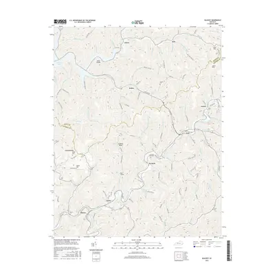
2016 Map of Blackey
USGS Topo · Published 2016About this map
Carcassonne and Carbon Glow sit within the hollows and high ridges of the Cumberland Plateau, defining a landscape shaped by coal heritage and deep mountain valleys. This 2016 survey of the Blackey area reveals a topography defined by steep contours and narrow drainages, where settlements like Jeremiah and Redfox follow the winding course of Rockhouse Creek and its many branches. The map includes the northern reach of the Carr Fork Lake reservoir, a significant water body in the northwestern corner that transformed the local geography of the Carr Creek community.
Find a feature on this map
110 named features on this map. Tap any name to fly to it.
Don’t see what you’re looking for? This feature index may not catch every label — zoom into the map to look around manually.
Map Details
Editions of this 2016 Blackey Map
This is the sole edition of this map. No revisions or reprints were ever made.
Other maps of this area

1890 · Whitesburg
USGS Topo · 1:125,000

1891 · Hazard
USGS Topo · 1:125,000

1892 · Whitesburg
USGS Topo · 1:125,000

1912 · Hindman
USGS Topo · 1:48,000

1913 · Oven Fork
USGS Topo · 1:48,000

1914 · Troublesome
USGS Topo · 1:62,500

1915 · Hindman
USGS Topo · 1:62,500

1915 · Whitesburg
USGS Topo · 1:62,500

1916 · Cornettsville
USGS Topo · 1:62,500
1935 · Pardee
USGS Topo · 1:24,000