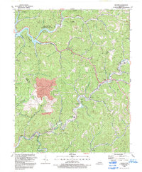
1992 Map of Blackey
USGS Topo · Published 1992About this map
The Kentucky River and its North Fork anchor the southern reaches of this Appalachian landscape, where the coal industry and rural settlement patterns are deeply intertwined. Centered around the communities of Blackey, Jeremiah, and Letcher, the map reveals a terrain heavily defined by mining operations, including a prominent strip mine near Carbon Glow. Cultural landmarks like the Dixon Memorial Ch and the Letcher Co High Sch serve as community hubs along the winding mountain roads. To the north, the waters of Carr Fork Lake and the surrounding Carr Fork Lake State Wildlife Mgmt Area offer a shift from the industrial character of the creek bottoms. Notable local features such as the Drive-in Theater near Sackett and the Whitesburg Municipal Airport provide evidence of the region's mid-century modernization within the steep valleys of the Knott and Letcher county line.
Find a feature on this map
59 named features on this map. Tap any name to fly to it.
Don’t see what you’re looking for? This feature index may not catch every label — zoom into the map to look around manually.
Map Details
Editions of this 1992 Blackey Map
This is the sole edition of this map. No revisions or reprints were ever made.
Other maps of this area

1890 · Whitesburg
USGS Topo · 1:125,000

1891 · Hazard
USGS Topo · 1:125,000

1892 · Whitesburg
USGS Topo · 1:125,000

1912 · Hindman
USGS Topo · 1:48,000

1913 · Oven Fork
USGS Topo · 1:48,000

1914 · Troublesome
USGS Topo · 1:62,500

1915 · Hindman
USGS Topo · 1:62,500

1915 · Whitesburg
USGS Topo · 1:62,500

1916 · Cornettsville
USGS Topo · 1:62,500
1935 · Pardee
USGS Topo · 1:24,000