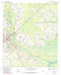
1971 Map of Blackshear East
USGS Topo · Published 1988About this map
The town of Blackshear serves as a focal point on this 1971 survey, showing the community's interface with the low-lying landscapes of Southeast Georgia. The Seaboard Coast Line railroad cuts diagonally across the terrain, passing through the small settlement of Owen and past the County Prison Farm. The geography is defined by a complex network of wetlands and watercourses, including the Alabaha River and the expansive Cross Swamp at the confluence with the Satilla River. Evidence of local industry is visible through multiple Sandpits and Sawmills scattered near the rail lines.
Find a feature on this map
35 named features on this map. Tap any name to fly to it.
Don’t see what you’re looking for? This feature index may not catch every label — zoom into the map to look around manually.
Map Details
Editions of this 1971 Blackshear East Map
2 editions found
Other maps of this area

1953 · Waycross
USGS Topo · 1:250,000

1958 · Waycross
USGS Topo · 1:250,000
1966 · Hoboken East
USGS Topo · 1:24,000

1967 · Hoboken West
USGS Topo · 1:24,000

1967 · Waycross East
USGS Topo · 1:24,000

1971 · Blackshear East
USGS Topo · 1:24,000

1971 · Patterson
USGS Topo · 1:24,000
1971 · Screven
USGS Topo · 1:24,000

1971 · Blackshear West
USGS Topo · 1:24,000

1971 · Mershon
USGS Topo · 1:24,000