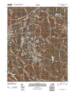
2010 Map of Blackstone East
USGS Topo · Published 2010About this map
The Fort Pickett Military Reserve dominates the southern landscape of this 2010 survey, reflecting the significant military presence in Nottoway County. The town of Blackstone serves as the primary hub, where the Blackstone Post Office and Allen C Perkinson Municipal Airport anchor the local community. The area is defined by an intricate network of waterways and managed reservoirs, including Butterwood Lake, Birchin Lake, and Camp Pickett Lake 3500. These water bodies, often regulated by structures like the Butterwood Lake Upper Dam and Birchin Dam, flow toward the Nottoway River at the quadrangle's southern edge. Smaller named locales like Dominy Corner and rural routes such as Yellow Bird Rd and Rocky Bump Rd provide specific geographic markers for those tracing family history or local developments in this portion of Virginia.
Find a feature on this map
65 named features on this map. Tap any name to fly to it.
Don’t see what you’re looking for? This feature index may not catch every label — zoom into the map to look around manually.
Map Details
Editions of this 2010 Blackstone East Map
This is the sole edition of this map. No revisions or reprints were ever made.
Other maps of this area

1891 · Farmville
USGS Topo · 1:125,000

1893 · Farmville
USGS Topo · 1:125,000

1897 · Amelia
USGS Topo · 1:125,000

1918 · Lawrenceville
USGS Topo · 1:62,500

1920 · Lawrenceville
USGS Topo · 1:48,000

1921 · Lawrenceville
USGS Topo · 1:62,500

1942 · Lawrenceville
USGS Topo · 1:62,500

1943 · Richmond
USGS Topo · 1:250,000

1947 · Roanoke
USGS Topo · 1:250,000

1949 · Richmond
USGS Topo · 1:250,000