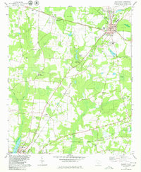
1979 Map of Blackville
USGS Topo · Published 1980About this map
Blackville serves as a central hub for the agricultural and transport networks of Barnwell County in the late 1970s, where the Southern railroad and several state highways converge. The landscape is a mosaic of cultivated fields and low-lying wetlands, drained by Turkey Creek and Toby Creek. Significant institutional footprints are visible, including the Edisto Experimental Sta (Clemson University) and the Jefferson Davis Academy. The rural character of the outlying area is defined by numerous country churches such as Double Pond Ch and Shrub Branch Ch, as well as family-named sites like Farrells Mill. The southern edge of the survey captures the outskirts of Barnwell, including the Hospital and Armory, while the Seaboard Coast Line cuts across the lower plains near Hilda. Barnwell State Park provides a notable preserved area within this active farming region.
Find a feature on this map
50 named features on this map. Tap any name to fly to it.
Don’t see what you’re looking for? This feature index may not catch every label — zoom into the map to look around manually.
Map Details
Editions of this 1979 Blackville Map
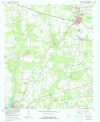
2 editions found
Other maps of this area

1919 · Olar
USGS Topo · 1:62,500

1919 · Bamberg
USGS Topo · 1:48,000

1919 · Allendale
USGS Topo · 1:62,500

1920 · Bamberg
USGS Topo · 1:62,500

1923 · Williston
USGS Topo · 1:48,000

1927 · Williston
USGS Topo · 1:62,500

1943 · Olar
USGS Topo · 1:62,500

1943 · Allendale
USGS Topo · 1:62,500

1943 · Bamberg
USGS Topo · 1:62,500

1943 · Williston
USGS Topo · 1:62,500