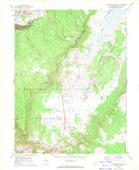
1968 Map of Blackwater Falls
USGS Topo · Published 1972About this map
Canaan Mountain and the high elevation floor of Canaan Valley dominate this landscape during a period of transition toward recreational land use in the late 1960s. The northern reaches of the Monongahela National Forest encompass the dramatic Blackwater Falls and the surrounding Blackwater Falls State Park, while the southern portion reveals the early development of Canaan Valley State Park, complete with its Golf Course. Industrial echoes remain via the Western Maryland tracks and a Strip Mine near the northern boundary, though the land increasingly favors conservation. Small agrarian settlements like Cortland and Canaan Heights sit amidst a complex hydrology of runs and forks, including the North Branch Blackwater River and Yoakum Run. Notable peaks such as Bearden Knob and the distinct Chimney Rock overlook the winding Blackwater River.
Find a feature on this map
39 named features on this map. Tap any name to fly to it.
Don’t see what you’re looking for? This feature index may not catch every label — zoom into the map to look around manually.
Map Details
Editions of this 1968 Blackwater Falls Map
3 editions found
Other maps of this area

1886 · St. George
USGS Topo · 1:125,000

1889 · Beverly
USGS Topo · 1:125,000

1891 · St. George
USGS Topo · 1:125,000

1892 · Beverly
USGS Topo · 1:125,000

1892 · Franklin
USGS Topo · 1:125,000

1895 · Piedmont
USGS Topo · 1:125,000

1896 · Franklin
USGS Topo · 1:125,000

1908 · Parsons
USGS Topo · 1:62,500

1916 · Davis
USGS Topo · 1:48,000

1918 · Davis
USGS Topo · 1:62,500