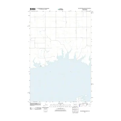
2011 Map of Blackwater Lake SE
USGS Topo · Published 2011About this map
Lake Sakakawea dominates the southern landscape of this North Dakota quadrangle, where the massive reservoir’s inlets and bays carve into the prairie. On the bluffs overlooking the water, Saint Andrews Cemetery remains a significant point of local history and genealogy near the winding drainage of the Missouri River basin. The upland terrain is defined by a rigid grid of rural corridors, including 14th St NW and 62nd Ave NW, which partition the landscape for agricultural use. This 2011 survey by the U.S. Geological Survey reflects the intersection of engineered water management and the enduring township-and-range road system that organizes this section of the state.
Find a feature on this map
12 named features on this map. Tap any name to fly to it.
Don’t see what you’re looking for? This feature index may not catch every label — zoom into the map to look around manually.
Map Details
Editions of this 2011 Blackwater Lake SE Map
This is the sole edition of this map. No revisions or reprints were ever made.
Other maps of this area

1954 · McClusky
USGS Topo · 1:250,000

1956 · Blackwater Lake NW
USGS Topo · 1:24,000

1956 · Blackwater Lake
USGS Topo · 1:24,000

1956 · Emmet
USGS Topo · 1:24,000

1958 · McClusky
USGS Topo · 1:250,000

1967 · Blackwater Lake SE
USGS Topo · 1:24,000

1967 · Blackwater Lake SW
USGS Topo · 1:24,000

1967 · Emmet SW
USGS Topo · 1:24,000

1969 · Beulah NE
USGS Topo · 1:24,000
1969 · Hazen NW
USGS Topo · 1:24,000