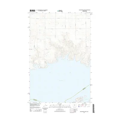
2014 Map of Blackwater Lake SE
USGS Topo · Published 2014About this map
Saint Andrews Cem sits on the northern bluffs overlooking the expansive waters of Lake Sakakawea in this 2014 survey. The landscape is defined by the dramatic meeting of the Missouri River reservoir and the high prairie plateaus of central North Dakota. A structured network of section-line roads, including 60th Ave NW and 13th St NW, crisscrosses the upland, providing access to the rugged draws and points that reach into the lake. Along the southern edge of the map, the McLean and Mercer County boundary runs through the open water and into Beulah Bay, marking a significant administrative divide in the middle of the reservoir. The presence of Bia 101 indicates the proximity of tribal lands and the ongoing importance of Bureau of Indian Affairs infrastructure in managing transit across these rural stretches.
Find a feature on this map
17 named features on this map. Tap any name to fly to it.
Don’t see what you’re looking for? This feature index may not catch every label — zoom into the map to look around manually.
Map Details
Editions of this 2014 Blackwater Lake SE Map
This is the sole edition of this map. No revisions or reprints were ever made.
Other maps of this area

1954 · McClusky
USGS Topo · 1:250,000

1956 · Blackwater Lake NW
USGS Topo · 1:24,000

1956 · Blackwater Lake
USGS Topo · 1:24,000

1956 · Emmet
USGS Topo · 1:24,000

1958 · McClusky
USGS Topo · 1:250,000

1967 · Blackwater Lake SE
USGS Topo · 1:24,000

1967 · Blackwater Lake SW
USGS Topo · 1:24,000

1967 · Emmet SW
USGS Topo · 1:24,000

1969 · Beulah NE
USGS Topo · 1:24,000
1969 · Hazen NW
USGS Topo · 1:24,000