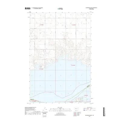
2018 Map of Blackwater Lake SE
USGS Topo · Published 2018About this map
Lake Sakakawea dominates the southern half of this landscape, its expansive waters defining the complex shoreline of North Dakota's prairie country. On the bluffs overlooking the water, Saint Andrews Cem stands as a quiet marker of the area's local heritage, situated just north of the lake's northern reaches. The terrain is characterized by the structured grid of rural section lines, including 14th St NW and Bia Rd 1, which navigate the undulating breaks leading down to the water. To the southeast, Beulah Bay creates a sheltered inlet where the land meets the reservoir at the junction of the McLean Co and Mercer Co line. This 2018 survey illustrates the intersection of modern infrastructure and the massive Missouri River impoundment, preserving the names of the local roads and sacred sites that remain above the waterline.
Find a feature on this map
14 named features on this map. Tap any name to fly to it.
Don’t see what you’re looking for? This feature index may not catch every label — zoom into the map to look around manually.
Map Details
Editions of this 2018 Blackwater Lake SE Map
This is the sole edition of this map. No revisions or reprints were ever made.
Other maps of this area

1954 · McClusky
USGS Topo · 1:250,000

1956 · Blackwater Lake NW
USGS Topo · 1:24,000

1956 · Blackwater Lake
USGS Topo · 1:24,000

1956 · Emmet
USGS Topo · 1:24,000

1958 · McClusky
USGS Topo · 1:250,000

1967 · Blackwater Lake SE
USGS Topo · 1:24,000

1967 · Blackwater Lake SW
USGS Topo · 1:24,000

1967 · Emmet SW
USGS Topo · 1:24,000

1969 · Beulah NE
USGS Topo · 1:24,000
1969 · Hazen NW
USGS Topo · 1:24,000