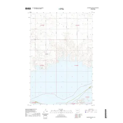
2020 Map of Blackwater Lake SE
USGS Topo · Published 2020About this map
The vast expanse of Lake Sakakawea and the winding Missouri River define the southern landscape of this 2020 North Dakota survey. Situated along the boundary of McLean and Mercer Counties, the map documents a terrain carved by water and organized by the Public Land Survey System, with township lines like t147n r88w and t148n r87w overlaying the high plains. For the genealogist or local historian, the map identifies several significant burial sites positioned near the shoreline and along the section roads, including Saint Pauls Church Cem, Sacred Heart Catholic Cem, and Saint Andrews Cem. The presence of Bia Rd 1 and various numbered section roads like 12th St NW shows the modern transportation network that services the rural homesteads and shorelines of Beulah Bay and the surrounding prairie bluffs.
Find a feature on this map
20 named features on this map. Tap any name to fly to it.
Don’t see what you’re looking for? This feature index may not catch every label — zoom into the map to look around manually.
Map Details
Editions of this 2020 Blackwater Lake SE Map
This is the sole edition of this map. No revisions or reprints were ever made.
Other maps of this area

1954 · McClusky
USGS Topo · 1:250,000

1956 · Blackwater Lake NW
USGS Topo · 1:24,000

1956 · Blackwater Lake
USGS Topo · 1:24,000

1956 · Emmet
USGS Topo · 1:24,000

1958 · McClusky
USGS Topo · 1:250,000

1967 · Blackwater Lake SE
USGS Topo · 1:24,000

1967 · Blackwater Lake SW
USGS Topo · 1:24,000

1967 · Emmet SW
USGS Topo · 1:24,000

1969 · Beulah NE
USGS Topo · 1:24,000
1969 · Hazen NW
USGS Topo · 1:24,000