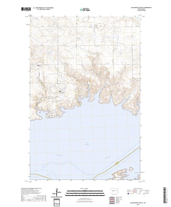
2024 Map of Blackwater Lake SE
USGS Topo · Published 2024About this map
Lake Sakakawea dominates the southern half of this landscape, where the inundated valley of the Missouri River meets the rolling upland plateaus of North Dakota. The map captures the quiet, rural character of the region, marked by a precise grid of sectional roads like 59th Ave NW and 14th St NW that define the agricultural landscape. For those researching local family histories, several vital landmarks are preserved on the sheet, including Saint Pauls Church Cem in the northwest and Sacred Heart Catholic Cem further south. Near the shoreline, Saint Andrews Cem overlooks the water, while the southeast corner opens into the recreational waters of Beulah Bay. The boundary between McLean and Mercer Counties is traced directly through the Missouri River channel, reflecting the geopolitical organization of the modern prairie.
Find a feature on this map
26 named features on this map. Tap any name to fly to it.
Don’t see what you’re looking for? This feature index may not catch every label — zoom into the map to look around manually.
Map Details
Editions of this 2024 Blackwater Lake SE Map
This is the sole edition of this map. No revisions or reprints were ever made.
Other maps of this area

1954 · McClusky
USGS Topo · 1:250,000

1956 · Blackwater Lake NW
USGS Topo · 1:24,000

1956 · Blackwater Lake
USGS Topo · 1:24,000

1956 · Emmet
USGS Topo · 1:24,000

1958 · McClusky
USGS Topo · 1:250,000

1967 · Blackwater Lake SE
USGS Topo · 1:24,000

1967 · Blackwater Lake SW
USGS Topo · 1:24,000

1967 · Emmet SW
USGS Topo · 1:24,000

1969 · Beulah NE
USGS Topo · 1:24,000
1969 · Hazen NW
USGS Topo · 1:24,000