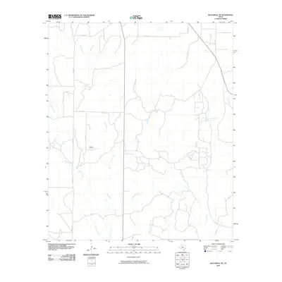
2010 Map of Blackwell NE
USGS Topo · Published 2010About this map
Decker Cemetery serves as a primary point of historical interest in this rural Nolan County landscape, positioned near the junction of several county roads and minor drainages. The terrain is characterized by a complex network of intermittent watercourses, where the headwaters of Oak Creek and Robertson Creek carve through the plains. The presence of Pecan Creek and North Branch Oak Creek suggests a landscape defined by seasonal water flow, which historically dictated the placement of ranch roads and remote homesteads.
Find a feature on this map
17 named features on this map. Tap any name to fly to it.
Don’t see what you’re looking for? This feature index may not catch every label — zoom into the map to look around manually.
Map Details
Editions of this 2010 Blackwell NE Map
This is the sole edition of this map. No revisions or reprints were ever made.
Other maps of this area

1893 · Sweetwater
USGS Topo · 1:125,000

1954 · Big Spring
USGS Topo · 1:250,000

1957 · Merkel
USGS Topo · 1:62,500

1958 · Big Spring
USGS Topo · 1:250,000

1967 · Hylton
USGS Topo · 1:24,000
1967 · Church Peak
USGS Topo · 1:24,000

1969 · Blackwell NE
USGS Topo · 1:24,000

1969 · Maryneal
USGS Topo · 1:24,000
1969 · Blackwell SW
USGS Topo · 1:24,000
1969 · Blackwell
USGS Topo · 1:24,000