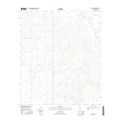
2016 Map of Blackwell NE
USGS Topo · Published 2016About this map
The Divide forms a prominent topographic feature across this portion of Nolan County, marking the high ground between numerous drainage systems that carve through the Texas landscape. The territory is defined by a dense network of seasonal watercourses, including Oak Cr, Pecan Cr, and Cottonwood Cr, which have shaped the local relief into a complex series of draws and ridges. Settlement patterns are sparse, primarily linked by a grid of rural routes such as Co RD 180 and Co RD 236. For genealogists and local historians, the Decker Cem provides a significant point of interest, standing as a quiet landmark amidst the expansive ranching or agricultural tracts. The map also traces more remote waterways like Cas Russell Cr and Salt Cr, illustrating the fundamental role of hydrography in defining land use and property boundaries in this part of West Texas.
Find a feature on this map
21 named features on this map. Tap any name to fly to it.
Don’t see what you’re looking for? This feature index may not catch every label — zoom into the map to look around manually.
Map Details
Editions of this 2016 Blackwell NE Map
This is the sole edition of this map. No revisions or reprints were ever made.
Other maps of this area

1893 · Sweetwater
USGS Topo · 1:125,000

1954 · Big Spring
USGS Topo · 1:250,000

1957 · Merkel
USGS Topo · 1:62,500

1958 · Big Spring
USGS Topo · 1:250,000

1967 · Hylton
USGS Topo · 1:24,000
1967 · Church Peak
USGS Topo · 1:24,000

1969 · Blackwell NE
USGS Topo · 1:24,000

1969 · Maryneal
USGS Topo · 1:24,000
1969 · Blackwell SW
USGS Topo · 1:24,000
1969 · Blackwell
USGS Topo · 1:24,000