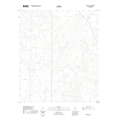
2019 Map of Blackwell NE
USGS Topo · Published 2019About this map
Decker Cem stands as a primary historical landmark in this West Texas landscape, situated west of the winding Oak Cr. The terrain is defined by a complex network of seasonal drainages, including Pecan Cr, Cottonwood Cr, and Robertson Cr, which carve through the high plains. A prominent geographic feature known as The Divide occupies the northeastern corner, marking the higher ground between watershed systems. This 2019 survey documents a sparsely populated rural landscape where cattle guards and county roads like Co RD 181 and Co RD 237 provide the primary infrastructure. The drainage patterns of Cas Russell Cr and S Fork Valley Cr reflect the arid character of Nolan County, where water is the primary architect of the land's relief.
Find a feature on this map
21 named features on this map. Tap any name to fly to it.
Don’t see what you’re looking for? This feature index may not catch every label — zoom into the map to look around manually.
Map Details
Editions of this 2019 Blackwell NE Map
This is the sole edition of this map. No revisions or reprints were ever made.
Other maps of this area

1893 · Sweetwater
USGS Topo · 1:125,000

1954 · Big Spring
USGS Topo · 1:250,000

1957 · Merkel
USGS Topo · 1:62,500

1958 · Big Spring
USGS Topo · 1:250,000

1967 · Hylton
USGS Topo · 1:24,000
1967 · Church Peak
USGS Topo · 1:24,000

1969 · Blackwell NE
USGS Topo · 1:24,000

1969 · Maryneal
USGS Topo · 1:24,000
1969 · Blackwell SW
USGS Topo · 1:24,000
1969 · Blackwell
USGS Topo · 1:24,000