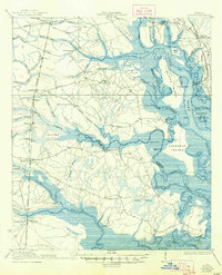
1939 Map of Bladen
USGS Topo · Published 1947About this map
Turtle River and the South Brunswick River dominate this coastal landscape at the edge of Glynn and Camden counties, where saltwater marshes and dense swamp forests meet early twentieth-century rail infrastructure. The intricate hydrology of the region is detailed through numerous named features like Buffalo Swamp, Bradley Swamp, and Whiteoak Swamp, which weave between small agricultural and timber-oriented settlements. This 1939 edition reflects a landscape still deeply tied to its maritime and rail connections, with the Atlantic Coast Line and Seaboard Air Line cutting through the terrain. Evidence of local community life is preserved in the locations of country schools such as Magnolia School and Buck Swamp School, alongside family-named landmarks like Hogans I and Gowrie Island. The coastal topography shows natural features like Fancy Bluff and Red Bluff overlooking the tidal creeks and islands, including the large expanse of Colonels Island.
Find a feature on this map
85 named features on this map. Tap any name to fly to it.
Don’t see what you’re looking for? This feature index may not catch every label — zoom into the map to look around manually.
Map Details
Editions of this 1939 Bladen Map
2 editions found

Other maps of this area

1917 · Nahunta
USGS Topo · 1:62,500

1917 · Boulogne
USGS Topo · 1:62,500

1918 · Cumberland Island
USGS Topo · 1:62,500

1918 · Hortense
USGS Topo · 1:62,500

1918 · Everett City
USGS Topo · 1:62,500

1918 · Nahunta
USGS Topo · 1:62,500

1918 · Bladen
USGS Topo · 1:62,500

1918 · Kingsland
USGS Topo · 1:62,500

1919 · Boulogne
USGS Topo · 1:62,500

1920 · Everett City
USGS Topo · 1:62,500