
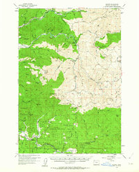
1955 Map of Blaine
USGS Topo · Published 1957About this map
Blaine sits along the winding course of the Nestucca River in this mid-century survey of the Oregon Coast Range. Much of the landscape is defined by the Siuslaw National Forest, where resource management and early recreation are visible through sites like the Trask Guard Sta, Trask House, and the Girl Scout Camp. The rugged topography is etched with numerous named drainages such as Fawcett Creek and Bark Shanty Creek, reflecting a region historically tied to timber and back-country access.
Find a feature on this map
68 named features on this map. Tap any name to fly to it.
Don’t see what you’re looking for? This feature index may not catch every label — zoom into the map to look around manually.
Map Details
Editions of this 1955 Blaine Map
2 editions found
Other maps of this area

1937 · Nehalem
USGS Topo · 1:62,500

1937 · Enright
USGS Topo · 1:62,500

1941 · Nestucca Bay
USGS Topo · 1:62,500

1941 · Timber
USGS Topo · 1:62,500

1941 · Enright
USGS Topo · 1:62,500

1942 · Ginger Peak
USGS Topo · 1:62,500

1942 · Sheridan
USGS Topo · 1:62,500

1942 · Spirit Mtn
USGS Topo · 1:62,500

1942 · Nestucca Bay
USGS Topo · 1:62,500

1942 · Fairdale
USGS Topo · 1:62,500