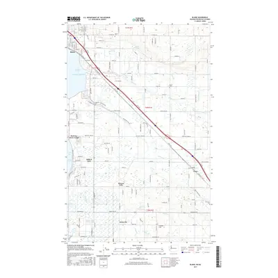
2017 Map of Blaine
USGS Topo · Published 2017About this map
Drayton Harbor and the northern reaches of Puget Sound define the coastal landscape of this Pacific Northwest border region. The settlement of Blaine sits at the northern edge, where the BNSF Railway and Peace Portal Dr serve as primary transportation corridors. Moving inland, the map captures a transition to the agricultural and residential districts of Birch Bay, Custer, and Kickerville.
Find a feature on this map
141 named features on this map. Tap any name to fly to it.
Don’t see what you’re looking for? This feature index may not catch every label — zoom into the map to look around manually.
Map Details
Editions of this 2017 Blaine Map
This is the sole edition of this map. No revisions or reprints were ever made.
Other maps of this area

1907 · Blaine
USGS Topo · 1:62,500

1952 · Bertrand Creek
USGS Topo · 1:24,000

1952 · Birch Point
USGS Topo · 1:24,000

1952 · Ferndale
USGS Topo · 1:24,000

1952 · Lummi Bay
USGS Topo · 1:24,000

1952 · Blaine
USGS Topo · 1:24,000

1952 · Blaine
USGS Topo · 1:62,500

1957 · Victoria
USGS Topo · 1:250,000

1975 · Bellingham
USGS Topo · 1:100,000
1997 · Lummi Bay
USGS Topo · 1:24,000