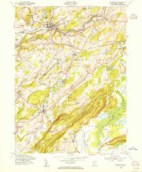
1954 Map of Blairstown
USGS Topo · Published 1955About this map
Blair Academy anchors the village of Blairstown in this mid-century survey, where the valley of Paulins Kill serves as a primary corridor for both the New York Susquehanna and Western and the Delaware Lackawanna and Western railroads. To the south, the dramatic ridge of Jenny Jump Mountain rises above Bear Swamp, housing the Jenny Jump State Forest and the industrial remnants of the Kishpaugh Mines. The map documents a landscape transitioning from its industrial roots to a recreational destination, evidenced by numerous camps such as Camp Hope and Camp Wasigan. Genealogists will find significant value in the clearly marked burial grounds, including the Moravian Cem in Hope and the Union Brick Cem near Ebenezer, alongside long-standing rural landmarks like Swayze Mills and Kerrs Corners.
Find a feature on this map
71 named features on this map. Tap any name to fly to it.
Don’t see what you’re looking for? This feature index may not catch every label — zoom into the map to look around manually.
Map Details
Editions of this 1954 Blairstown Map
4 editions found
Other maps of this area

1888 · Hackettstown
USGS Topo · 1:62,500

1891 · Wallpack
USGS Topo · 1:62,500

1891 · Delaware Water Gap
USGS Topo · 1:62,500

1893 · Delaware Water Gap
USGS Topo · 1:62,500

1893 · Wallpack
USGS Topo · 1:62,500

1894 · Hackettstown
USGS Topo · 1:62,500

1898 · Hackettstown
USGS Topo · 1:62,500

1900 · Raritan
USGS Topo · 1:125,000

1905 · Raritan
USGS Topo · 1:125,000

1905 · Hackettstown
USGS Topo · 1:62,500
Featured Places
- Blairstown, NJ
- Allamuchy Township, NJ
- Hope Township, NJ
- Hardwick Township, NJ
- Marksboro, Frelinghuysen Township