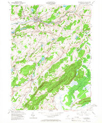
1954 Map of Blairstown
USGS Topo · Published 1967About this map
Blair Academy anchors the village of Blairstown at the confluence of Blair Creek and the Paulins Kill, illustrating a landscape where educational institutions and small-scale industry defined the community. The northern reach of the Jenny Jump Mountain ridge dominates the southern half of the map, sheltering the Jenny Jump State Forest and the industrial remnants of the Kishpaugh Mines. Transportation networks are well-defined by the New York Susquehanna and Western and the Delaware Lackawanna and Western railroads, which follow the natural river valleys. Genealogists will find several burial sites including Cedar Ridge Cem, Moravian Cem, and the Swayze Cem near the settlement of Swayzes Mills. The area's transition into a mid-century recreation hub is evidenced by numerous camps like Camp Hope and Camp Wasigan scattered among the many small lakes.
Find a feature on this map
65 named features on this map. Tap any name to fly to it.
Don’t see what you’re looking for? This feature index may not catch every label — zoom into the map to look around manually.
Map Details
Editions of this 1954 Blairstown Map
4 editions found
Other maps of this area

1888 · Hackettstown
USGS Topo · 1:62,500

1891 · Wallpack
USGS Topo · 1:62,500

1891 · Delaware Water Gap
USGS Topo · 1:62,500

1893 · Delaware Water Gap
USGS Topo · 1:62,500

1893 · Wallpack
USGS Topo · 1:62,500

1894 · Hackettstown
USGS Topo · 1:62,500

1898 · Hackettstown
USGS Topo · 1:62,500

1900 · Raritan
USGS Topo · 1:125,000

1905 · Raritan
USGS Topo · 1:125,000

1905 · Hackettstown
USGS Topo · 1:62,500
Featured Places
- Blairstown, NJ
- Allamuchy Township, NJ
- Hope Township, NJ
- Hardwick Township, NJ
- Marksboro, Frelinghuysen Township