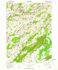
1954 Map of Blairstown
USGS Topo · Published 1962About this map
Blair Academy anchors the village of Blairstown at the northern edge of this Warren County landscape, situated where the New York Susquehanna and Western RR meets the Paulins Kill. The map reveals a mid-century rural economy transitioning from industrial roots toward recreation and conservation, evidenced by the scattered camps such as Camp Wasigan and Camp Hope alongside the massive ridge of Jenny Jump Mountain.
Find a feature on this map
73 named features on this map. Tap any name to fly to it.
Don’t see what you’re looking for? This feature index may not catch every label — zoom into the map to look around manually.
Map Details
Editions of this 1954 Blairstown Map
4 editions found
Other maps of this area

1888 · Hackettstown
USGS Topo · 1:62,500

1891 · Wallpack
USGS Topo · 1:62,500

1891 · Delaware Water Gap
USGS Topo · 1:62,500

1893 · Delaware Water Gap
USGS Topo · 1:62,500

1893 · Wallpack
USGS Topo · 1:62,500

1894 · Hackettstown
USGS Topo · 1:62,500

1898 · Hackettstown
USGS Topo · 1:62,500

1900 · Raritan
USGS Topo · 1:125,000

1905 · Raritan
USGS Topo · 1:125,000

1905 · Hackettstown
USGS Topo · 1:62,500
Featured Places
- Blairstown, NJ
- Allamuchy Township, NJ
- Hope Township, NJ
- Hardwick Township, NJ
- Marksboro, Frelinghuysen Township