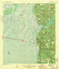
1943 Map of Blakeley
USGS Topo · Published 1943About this map
Civil War Trenches and Kings Battery mark the heights above the Blakeley River, overlooking a complex delta where the Tensaw River and Apalachee River meet Mobile Bay. This 1943 edition reflects a landscape shaped by military history and the expansion of early 20th-century transportation. The Cochrane Bridge and Old Spanish Trail cut a straight path across the wetlands of Blakeley Island, connecting the industrializing bayfront to the eastern shore. Genealogists will find interest in the Blakeley Cem near the site of Blakeley, as well as the D'Olive Cem further south. The intricate network of waterways, including Chacaloochee Bay and Bay Minette Basin, illustrates the difficult terrain that defined the region's development before modern drainage and infrastructure projects.
Find a feature on this map
57 named features on this map. Tap any name to fly to it.
Don’t see what you’re looking for? This feature index may not catch every label — zoom into the map to look around manually.
Map Details
Editions of this 1943 Blakeley Map
2 editions found
Other maps of this area

1921 · Fairhope
USGS Topo · 1:62,500

1922 · Mobile
USGS Topo · 1:62,500

1939 · Daphne
USGS Topo · 1:31,680

1940 · Silverhill
USGS Topo · 1:31,680

1940 · Hollingers Island
USGS Topo · 1:31,680

1940 · Mobile
USGS Topo · 1:31,680

1940 · Mobile
USGS Topo · 1:62,500

1941 · Chickasaw
USGS Topo · 1:31,680

1941 · Daphne
USGS Topo · 1:31,680

1941 · Silverhill
USGS Topo · 1:31,680