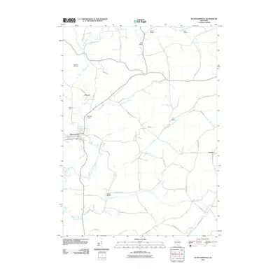
2010 Map of Blanchardville
USGS Topo · Published 2010About this map
Blanchardville sits at the heart of this landscape, where the Blanchardville Post Office and Bakers Field serve as local anchors. The village is positioned along the winding course of Gordon Creek, which is regulated to the north by the McCoy G 9648 Dam. The surrounding terrain is a network of ridges and drainages, including Jeglum Valley, Step Valley, and McPeace Valley. This rural landscape is dotted with small settlements like Moscow and Postville, connected by a web of county highways and local roads such as Yankee Hollow Rd and Loyalty Rd.
Find a feature on this map
50 named features on this map. Tap any name to fly to it.
Don’t see what you’re looking for? This feature index may not catch every label — zoom into the map to look around manually.
Map Details
Editions of this 2010 Blanchardville Map
This is the sole edition of this map. No revisions or reprints were ever made.
Other maps of this area

1920 · Monroe
USGS Topo · 1:62,500

1922 · Monroe
USGS Topo · 1:62,500

1923 · Blanchardville
USGS Topo · 1:62,500

1923 · New Glarus
USGS Topo · 1:62,500

1923 · South Wayne
USGS Topo · 1:62,500

1954 · Rockford
USGS Topo · 1:250,000

1955 · Rockford
USGS Topo · 1:250,000

1958 · Rockford
USGS Topo · 1:250,000
1962 · New Glarus
USGS Topo · 1:62,500
1962 · Monroe NW
USGS Topo · 1:24,000