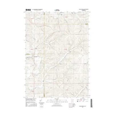
2016 Map of Blanchardville
USGS Topo · Published 2016About this map
The E Pecatonica River winds through this landscape on the border of Iowa, Dane, Green, and Lafayette counties. Centered on the village of Blanchardville, the terrain is defined by a dense network of coulees and valleys, including Kittleson Valley, Lee Valley, and McPeace Valley. These landforms dictate the winding paths of local routes like Moscow Rd and York Valley Rd.
Find a feature on this map
74 named features on this map. Tap any name to fly to it.
Don’t see what you’re looking for? This feature index may not catch every label — zoom into the map to look around manually.
Map Details
Editions of this 2016 Blanchardville Map
This is the sole edition of this map. No revisions or reprints were ever made.
Other maps of this area

1920 · Monroe
USGS Topo · 1:62,500

1922 · Monroe
USGS Topo · 1:62,500

1923 · Blanchardville
USGS Topo · 1:62,500

1923 · New Glarus
USGS Topo · 1:62,500

1923 · South Wayne
USGS Topo · 1:62,500

1954 · Rockford
USGS Topo · 1:250,000

1955 · Rockford
USGS Topo · 1:250,000

1958 · Rockford
USGS Topo · 1:250,000
1962 · New Glarus
USGS Topo · 1:62,500
1962 · Monroe NW
USGS Topo · 1:24,000