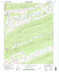
1968 Map of Bland
USGS Topo · Published 1978About this map
Bland serves as the focal point of this southwestern Virginia landscape, situated where Crab Orchard Creek meets the headwaters of the valley. The terrain is defined by the massive parallel ridges of Walker Mountain and Little Walker Mountain, both contained within the Jefferson National Forest. This 1960s survey, updated with late 1970s aerial data, reveals a community structure rooted in small family-named landmarks and mountain gaps.
Find a feature on this map
29 named features on this map. Tap any name to fly to it.
Don’t see what you’re looking for? This feature index may not catch every label — zoom into the map to look around manually.
Map Details
Editions of this 1968 Bland Map
Other maps of this area

1887 · Pocahontas
USGS Topo · 1:125,000

1889 · Hillsville
USGS Topo · 1:125,000

1889 · Wytheville
USGS Topo · 1:125,000

1890 · Dublin
USGS Topo · 1:125,000

1891 · Pocahontas
USGS Topo · 1:125,000

1891 · Dublin
USGS Topo · 1:125,000

1892 · Hillsville
USGS Topo · 1:125,000

1892 · Wytheville
USGS Topo · 1:125,000

1894 · Pocahontas
USGS Topo · 1:125,000

1895 · Pocahontas
USGS Topo · 1:125,000