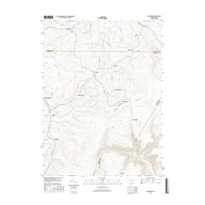
2016 Map of Blandburg
USGS Topo · Published 2016About this map
Clearfield Creek winds through the western reaches of this Pennsylvania landscape, where the borders of Clearfield, Cambria, and Blair counties meet. The settlement pattern is defined by several small communities such as Blandburg, Glasgow, and Utahville, connected by a network of rural roads like Viola Pike and Janesville Pike. Water resources are a prominent feature of the terrain, including the Sandy Run Reservoir and the Bellwood Reservoir at the southern edge of the survey area. Local history and genealogy interest is concentrated around sites such as the Criswell Cem and Cambria Mills Cem. The presence of Railroad St in Blandburg and various old mill roads indicates the region's industrial past, while the plateau of Pancake Flats and the numerous runs—such as Powell Run and Fallentimber Run—illustrate the complex drainage patterns of the Allegheny Front.
Find a feature on this map
53 named features on this map. Tap any name to fly to it.
Don’t see what you’re looking for? This feature index may not catch every label — zoom into the map to look around manually.
Map Details
Editions of this 2016 Blandburg Map
This is the sole edition of this map. No revisions or reprints were ever made.
Other maps of this area

1902 · Patton
USGS Topo · 1:62,500

1903 · Curwensville
USGS Topo · 1:62,500

1903 · Houtzdale
USGS Topo · 1:62,500

1904 · Patton
USGS Topo · 1:62,500

1905 · Houtzdale
USGS Topo · 1:62,500

1920 · Altoona
USGS Topo · 1:62,500

1922 · Altoona
USGS Topo · 1:62,500

1939 · Curwensville
USGS Topo · 1:62,500

1942 · Curwensville
USGS Topo · 1:62,500

1943 · Punxsutawney
USGS Topo · 1:125,000
Featured Places
- Beccaria Township, PA
- Dean Township, PA
- Clearfield Township, PA
- Bear Loop, Reade Township
- Blandburg, Reade Township